 Live Music Archive
 Librivox Free Audio
 Metropolitan Museum
 Cleveland Museum of Art
 Internet Arcade
 Console Living Room
 Books to Borrow
 Open Library
 TV News
 Understanding 9/11
tv Fox 5 News Edge at 11 FOX October 26, 2012 11:00pm-11:30pm EDT
11:00 pm

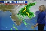
of your supporters out to actually vote whether it's early day voting or election day voting than the other side gets with their supporters. >> chris wallace, we'll see you this sunday at 9 a.m. on fox news sunday. thanks. >> thank you for joining us tonight. here's brian now with the news edge at 11:00. hurricane sandy may become a tale of two storms, first sandy battered the beaches in the caribbean in south florida with waves strong enough to pull cars into the ocean. now it's moving north and is expected to collide with a cold air mass to create a hybrid monster storm. residents from the mid-atlantic to new england have their eyes on this thing and fox 5 is covering it from every angle. we'll hear from local leaders, metro, homeowners, but first we have the new 11:00 forecast from the national hush center. sue palka is in the weather -- hurricane center. sue palka is in the weather center pour over it now. >> they're -- pouring over it
11:01 pm
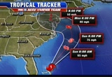
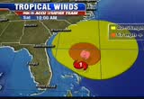
now. >> they're definitely talking about this taking over the characteristics of the hybrid storm it is predicted to become. they keep it as a category 1 hurricane and it's moving faster now to the north at 10 miles per hour. so that picked up a small amount of forward motion, but they think the center has been wobbly a little bit as we've gone overnight. in the short term the track has shifted slightly to the east in the next, oh, say 24 to 48 hours. after that they still keep that hard westward motion as it likely will still make a landfall somewhere around delaware, southern new jersey. so the track essentially in the later hours did not change very much. it is well inland. you can see there tuesday at 8:00 with 50-mile an hour winds in south central pennsylvania and it moves up to new york state by wednesday evening with strong winds of 40 miles an hour, but again very heavy rain expected with the system. so essentially in the later hours and for our intents and purposes that cone didn't
11:02 pm
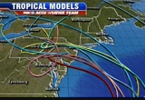
change too much, might have got expanded a little farther to the eastern side of it. it looks like it's going up almost to the line with maine there. so that cone remains a very important part of the forecast because there will still in the next 24 to 36 hours be some fluctuations in that. wanted to show you also the spaghetti models. we saw this just happen at 10:45. a lot of them now are again a little bit to the north of d.c. the red line being the national hurricane center track, but they still all take that turn. they still all have it meandering and kind of doing a loop de loop somewhere over pennsylvania. that is an interesting shift, cult, but a lot of those models -- subtle, but a lot of those models are a bit farther north than they were. quick look at the headlines, going downhill mainly sunday evening with the rain and wind picking up, peak effect monday and tuesday.
11:03 pm

we expect torrential rain on the order of several inches, damaging wind gusts strong enough that we should be preparing for the possibility of power outages that could last a number of days. we'll have much more in a few minutes. currently maryland, virginia and the district all under a state of emergency. that means local and state governments can activate the national guard and provide extra assistance if needed. d.c. mayor vincent gray joined us on fox 5 news at 10:00 to tell us how the district is getting ready. >> we're also really working hard to get as many leaves off the ground as we possibly can because if those leaves start to go down into the catch basin and storm drains, they'll clog it up and cause even more flooding than we otherwise would have had. >> gray said he's spoken with pepco about how to prevent another massive power outage like this summer. pepco is bringing in additional crews. the rush is on at local hardware stores as homeowners
11:04 pm
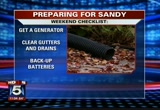
race to get ready. there are some key things you can do to weather this storm with minimal dang. will thomas has that now. -- damage. will thomas has that now. >> we spoke with the manager of bethesda hardware tonight. he said people tend to do the bare minimum like stock up on batteries and flashlights, but this time he gave us a checklist you can run through before the weather turns bad. first up buy a generator or make sure yours is working. wen they're not cheap, but he says -- we know they're not cheap, but he says if you can swing it, in the long run it will pay off over many uses. you want to make sure there aren't any leaves blocking the water flow to your storm drain and if you have a basement, make sure you have a backup battery for your sump pump. >> everybody panics, but it's like the winter is early this year. >> last time we lost power it was two or three days before it
11:05 pm

was restored. so hopefully it won't be the same this time. >> here's another suggestion that could save you a messy clean-up later. bring in your halloween decorations or political signs. you can always put them back up after the weather clears. some folks are beginning to stock up for sandy. we caught up with some shoppers at the brentwood giant in d.c. this evening buying essentials they say they'll go through during the storm. >> well, we have french fries, pizza, chips, hamburgers, cereal for breakfast that's good for you. >> reporter: how worried are you about this storm coming? >> i'm just going to deal with it as it comes. i put everything in god's hands right now and everything is going to be all right. >> besides people stocking up on food, some area hardware stores say they've had a lot of customers today, people buying up flashlights and batteries. metro getting ready for
11:06 pm

this big storm. joining us right now on the phone is metro spokesman dan stessel. thanks for joining us. you are still continuing to do track work this weekend. is that right? >> yeah, hi, brian. we are planning to proceed with track work as scheduled, though we will closely monitor conditions thugh the day sunday. if conditions deteriorate significantly, we may reevaluate that, but from a customer perspective, they should plan on the scheduled track work taking place as scheduled. >> we know the heat and snow impacts you and heavy rains and flooding affect some of the train stations and tracks. what are you doing to protect those? >> right. that's where we've been focused the last 48 hours. last night crews laid sandbags at some critical locations, vent shafts around some of those locations where we have a history of water infiltrating the tunnels. we've checked all our drainage pumping stations to ensure they're in good working order and will have personnel monitoring those through the
11:07 pm

storm. >> can you share with us some of those stations that have a history of trouble during flooding? >> yeah. the two most significant are cleveland park on the red line and federal triangle as well where if you go to those stations now, you'll find sandbags around the vent shafts to prevent water from going into the station. closer to the storm you may find sandbags ringing the escalators to prevent water from flowing down the escalators into the station. >> you can follow the storm's path on myfoxhurricane.com. there you'll find enhanced satelli images, interactive models, a live chat and more. breaking news from maryland a husband and wife were shot while walking down a quiet street, the live report next. >> and sue is tracking the storm. >> don't be surprised if tomorrow you hear sandy is down graded to a tropical storm. that is expected, but as it get closer to americaning with that system, it is expected -- merging with that system, it is expected to get gonger again. we'll have your fox 5
11:08 pm

accuweather seven-day forecast in just moments -- stronger again. we'll have your fox 5 accuweather seven-day forecast in just moments. stick with us. >> this is fox 5 news edge at 11:0 anncr: their ads, hopelessly untrue.
11:09 pm

a west virginia casino launching the biggest ad barrage ever. don't be misled. the washington post says question seven is just... common sense. it'll create 4,000 permanent jobs. and stop maryland from losing millions to other states... every year. that's why business, labor, and teachers all support... question seven. and so does the washington post. vote for question seven. it's just common sense.
11:10 pm
following breaking news from charles county, maryland where a wife was killed in front of her husband tonight, the gunman still on the run. fox 5's audrey barnes joins us live from the scene in waldorf. what's the latest? >> reporter: a couple in their 40s was out walking their dog
11:11 pm

about 7:15 tonight on this popular footpath that leads from the neighborhood to westlake high school. there was a football game going on at the high school at the time and officers working at that game heard the shots and rushed here to the scene to help and they found the couple that had been shot multiple times. the man was able to give them a very disturbing account of what happened here and we just heard that account from police just moments ago. they tell us that he and his wife encountered a lone gunman on this path and when their dog, a boxer, barked at this man, he unloaded his gun shooting them multiple times. now the wife did die at the hospital. the man is in serious condition and this community is on edge. >> you can see the presence of the police department all over the neighborhood and it's tragic, the first time that something like this happened. it's been a very quiet neighborhood for 24 years. >> reporter: now police do have a very vague description of the suspect, but they
11:12 pm

believe someone in this community might have seen something as well. there were a lot of people out. it was a beautiful evening, a lot of people out walking their dogs and playing with their kids. so someone might have seen someone fleeing from the scene. they would love to hear from you. there is a $5,000 reward for information that helps police catch the suspects in this case. back to you, brian. incremental news tonight, but some of the tracks are shifting northward a bit. >> interesting now. hurricane center didn't make any changes. it will be interesting to see if they make any changes tomorrow. we're still a couple days away. the worst of this we believe will be monday night through tuesday. live look outside, a beautiful evening following a fantastic week, but the clouds tomorrow will stick thickly with us. there might be a couple sun breaks, might be a spotty shower or, so but your saturday is going to be good for getting a lot of extra work done around
11:13 pm
the house to get yourself ready. will thomas went through a big list with you earlier. make sure you gas up your car just in case we have power outages. that was something that took a lot of people by surprise during the derecho when gas stations couldn't pump gas. maybe get a little cash, too, if stores are out of power and you need to buy something. it's still a hurricane with winds at 75 miles an hour 395 miles to the south, southeast of charleston, definitely looks raggedy. there's a lot more thunderstorm activity on the north and western side and it's encountering wind sheer which is kind of blowing it apart. even though it may weaken tomorrow and you hear about tropical storm sandy versus hurricane sandy, don't let down your guard because we do believe it will intensify back to a hurricane before it becomes this monster storm, the nor'easter we're expecting. we definitely have some clouds, a couple spotty showers to our south. i think that's how it will look for a good deal of tomorrow and then you can see our stronger
11:14 pm
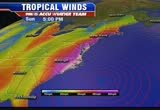
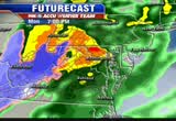
cold front producing showers. some of that rain will be in pittsburgh sunday. so it's going to be a cold rain for them, about the it's when these two systems merge that we're talking about increasing rain and importantly increasing wind and that's where gary mcgrady will pick up this part of the forecast because wind definitely will be a big deal. >> absolutely. as this comes ashore and gets closer to us, that's when i think the winds will really begin to kick up on a broad scale. showing you this, we have one of our models in red, the closed off circle there indicating the center of circulation. that's going to come up. as we see this big trough digging out to the west, that's actually going to bring the storm in and provide cold air aloft and strngthen the storm and expand the wind field. the way it looks right now most of the wind that we get here in the mid-atlantic will be coming from the west and northwest and even there's a northerly
11:15 pm
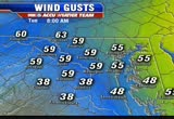
component as well. right now the wind coming up from the south and southeast will be piling up all that water for jersey up to long island and up to providence and around towards the cape. that's the way it looks right now, but again this could all changed based on the differences in the models and what this storm will do. as we get into wednesday and thursday while the storm will still be present, hopefully by then it will begin to weaken. tuesday morning 8 a.m. these are wind gusts projected by our models, 59 miles per hour, 60 miles per hour. there's hagerstown 63. keep in mind this is not a specific number. it gives a range of the wind gusts we could be seeing and that continues right through the day tuesday. it will weaken a little bit, but after several hours 50, 60 mile-per-hour wind gusts once it comes down to 45 to 50, that's not a whole heck of a lot. we will be in probably a 24 to 36 hour period here where we can actually end up with wind
11:16 pm

gusts anywhere between 30 and 60 miles per hour and that is no doubt the kind of wind that's going to bring down trees, bring down power lines. it will cause some power outages, huge impact with this storm from the mid-atlantic up to the northeast. >> that's why we're potentially saying this is going to be historic because not just here, but multiple states seeing this with potential wind damage from those prolonged winds and we'll get a lot of rain out of this thing and it will weaken these trees. be aware of that. that's my biggest concerns are those trees coming down. 63 degrees is our temperature now. i wanted you to see the contrast, the colder part of this system coming into may over the weekend, 47 in columbus, 43 degrees in chicago and it's destined to fall. we have winter storm watches in the western portions of the appalachians, but rainfall will be a big story. it will begin sunday. we've got a couple showers saturday as well, but the bulk of it especially to our south
11:17 pm
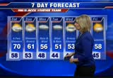
and east, 6 to 8 inches or more in the metro area, 4 to 6 inches and off to our west it could be 2 to 4 with 8 to 10 inches of snow potential in the mountains, maybe even a foot of snow in the mountains. for tonight 58 degrees, a few clouds, maybe a little fog overnight. saturday looks okay, a lot of clouds around, maybe a bit of drizzle or light shower, late day sunshine possible. our temperature tomorrow gets up to 70 degrees and your fox 5 accuweather seven-day forecast looks like this. again forecasting 70 tomorrow, get your running around done and preparations finished, showers and breezy sunday. the rain will be heavier into the later portion of the day and especially after the sun goes down. rain and wind monday and tuesday. that's when we'll get the bunt of what we'll get with our hurricane -- brunt of what we'll get with our hurricane sandy. showers are possible, 53 degrees. thursday and friday looks a whole lot different than this week. and it's going to look a lot different in pittsburgh
11:18 pm

where the skins will be having to play nd temperatures in the 40s. lindsay murphy has more. >> this is the verizon 4g lte with lindsay murphy. >> we'll hit the road tomorrow for pittsburgh without wide receiver pierre garcon and safety brandon meriweather. london fletcher is questionable to may battling a sore hamstring and balance issues. fletcher does not have a concussion but is still being watched for balance problems. fletcher did have a full practice today, the first time all week. he will continue to be watched the next 48 hours to see if he's able to play. at this time, though, his streak of 231 consecutive games played could be in jeopardy, but as always safety first. >> well, no. 1, he's got to feel comfortable because you can't go out there if you've got balance issues and play. everybody knows that, but relative to the hamstring i
11:19 pm

can't tell you until probably 48 hours from now or close to it when he works out before the game and he tries to push it harder than he did today. >> it does not get any easier for the defense this week. their next task, to try and slow down big ben roethlisberger, the steelers signal caller coming off a solid sunday performance in cincinnati 27 of 37, 278 yards and this touchdown to tight end heath miller. he has won two super bowl titles since joining the steelers in 2004 and the redskins know he will not be pretty easy to take down. >> ben is a guy that can extend the play. he's not going to scramble, but he's creative in that backfield and he has a decent line you've got to rush, six, seven seconds as opposed to two or three when you expect the ball to come out. the play is going to keep going. we'll have a lot of bodies rolling in and out. switching gears today was the wizards final preseason game.
11:20 pm

they entered the game against the spurs with a 3-4 record so far without john wall. they will tip off regular season tuesday at the cleveland cavaliers. and the wizards, this is their final preseason tuneup tonight in san antonio. it was the second year guy john vesely off the pick and roll. the wizards had a 13 point lead, but in the 2nd half the prosecutors would take over. good ball movement here, back to the top of the key -- the spurs would take over. good ball movement here. back to the top of the keys. the season starts for real on tuesday. when we come back, fighting night is tomorrow night at the patriot center. we'll hear from local product jimmy lang, that guy, after the break. in this country. and we face this deficit -- could crush the future generations. and republicans and democrats both love america but we need to have leadership -- leadership in washington that will actually bring people together and get the job done
11:21 pm

and could not care less if it's a republican or a democrat. i've done it before, i'll do it again. i'm mitt romney, and i approve this message.

11:23 pm

326 nhl games have now been lost. all games through november 30th have been canceled and the prospect of a full regular season has now been lost. as of right now, 26% of the season has been wiped out. the league's most recent offer including a 50/50 split of revenues with the players has also been taken off the table because this will not be a full regular season. switching gears, good crowd on hand at the green turtle in fairfax for the official weigh- in with jimmy lang, the middle weight bout at the patriot center tomorrow. lang came into the fox 5 studios a week ago when dave ross caught up with him to see how things had changed. >> a week and a half ago we had
11:24 pm

you on. now we're 24 hours away. how do you feel? >> i'm a little nastier than before. >> that's a good kind of nasty, right? >> absolutely. we're not going to the homecoming dance. it will be a good night. >> we're not going to homecoming dance, final words from jimmy lang. congrats to our producer rich dunn into i ducks into the hall of -- on his induction into the sports hall of fame today. we'll be right back. where others fail, droid powers through. introducing the new droid razr maxx hd by motorola. now more than ever droid does.


11:27 pm
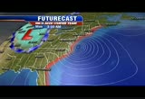
simple hurricane sandy moving north on a path -- hurricane sandy moving north on a path. most expect it to hit the east coast. it's just a matter of where. >> we're all at hook anywhere from southeastern virginia up to new england. this was updated at 11:00, too and you can see our category 1 storm still spinning down there, but watch the area in yellow. let's give you an idea when we can expect the worst of these winds. we'll be okay tomorrow, might be breezy, most of sunday okay, but in terms of the wind we'll really start to see it ticking up along the coastline monday and as we go through the day monday that starts moving into our area. our landfalling system will be sometime monday night into tuesday and those big winds will continue and you can see those really stronger gusts in the orange along the coast. it will be really rough at the beaches. in terms of rain looks like most of the day tomorrow will
11:28 pm
be dry. we could pick up a spotty shower, but if you want to do some traveling, you'll be okay most of saturday. outer banks might be a different story, southeastern virginia might be a different story. we get into norfolk sunday, 8 a.m., it's starting to rain there. we will likely see our rain picking up in intensity in the afternoon, but it's really sunday night we start seeing some of that heaviest rain come in and certainly during the day monday. watch the snow starting to grow in the applications as i show you all this. monday afternoon raining hard, torrential rain continuing into tuesday and here is your fox 5 accuweather seven-day forecast. we're talking about most of the worst of this on monday and tuesday. hopefully we can kick it out of here for wednesday, halloween. >> now you have the news edge. of course, the news is always on www.myfoxdc.com. check it. it's got our live radar on it. you can watch it all weekend long. sue and the weather team will be here all weekend long as well watching the storm for you. have a fantastic weekend.
11:29 pm

see you. >> fuehrer isn't over. go to www.myfoxdc.com now for news, weather and entertainment updates. fox 5 news is washington's best news on air and online at www.myfoxdc.com brought to you beaverrer is. you-- by verizon 4g lte.
204 Views
IN COLLECTIONS
WTTG (FOX) Television Archive
  Television Archive News Search Service
Uploaded by TV Archive on
